


jg-29

Jack-94
User
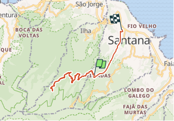

Length
19 km

Max alt
1088 m

Uphill gradient
1339 m
Km-Effort
39 km

Min alt
384 m

Downhill gradient
1845 m
Boucle
No
Creation date :
2024-06-11 08:51:58.566
Updated on :
2024-06-11 15:11:22.566
6h18
Difficulty : Very difficult

FREE GPS app for hiking
 SityTrail
IGN / Geographical institutes
SityTrail Plus
The world is yours!
About
Trail Walking of 19 km to be discovered at Madeira, Unknown, Santana. This trail is proposed by Jack-94.
Positioning
Country:
Portugal
Region :
Madeira
Department/Province :
Unknown
Municipality :
Santana
Location:
Unknown
Start:(Dec)
Start:(UTM)
321506 ; 3628942 (28S) N.
Comments