


240511 Cascades de Tendon

guy284
User
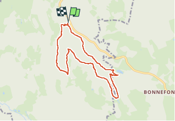

Length
8 km

Max alt
699 m

Uphill gradient
271 m
Km-Effort
11.6 km

Min alt
506 m

Downhill gradient
272 m
Boucle
Yes
Creation date :
2024-06-11 12:11:01.655
Updated on :
2024-06-11 15:17:44.966
2h13
Difficulty : Very easy

FREE GPS app for hiking
 SityTrail
IGN / Geographical institutes
SityTrail Plus
The world is yours!
About
Trail Walking of 8 km to be discovered at Grand Est, Vosges, Tendon. This trail is proposed by guy284.
Positioning
Country:
France
Region :
Grand Est
Department/Province :
Vosges
Municipality :
Tendon
Location:
Unknown
Start:(Dec)
Start:(UTM)
327462 ; 5331248 (32U) N.
Comments