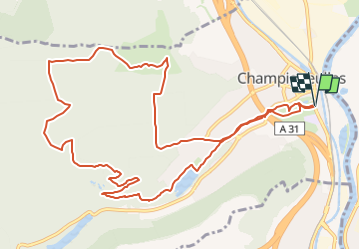
Champigneulles_12,5km

ZAMBAUX
User

Length
12.5 km

Max alt
361 m

Uphill gradient
216 m
Km-Effort
15.4 km

Min alt
196 m

Downhill gradient
218 m
Boucle
Yes
Creation date :
2024-06-12 16:27:22.733
Updated on :
2024-06-12 16:28:29.071
3h29
Difficulty : Difficult

FREE GPS app for hiking
 SityTrail
IGN / Geographical institutes
SityTrail Plus
The world is yours!
About
Trail Walking of 12.5 km to be discovered at Grand Est, Meurthe-et-Moselle, Champigneulles. This trail is proposed by ZAMBAUX.
Description
Randonnée en boucle en passant près du fort de Frouard
Positioning
Country:
France
Region :
Grand Est
Department/Province :
Meurthe-et-Moselle
Municipality :
Champigneulles
Location:
Unknown
Start:(Dec)
Start:(UTM)
291837 ; 5401414 (32U) N.
Comments