


boucle écluse de Portiragnes vers Portiragnes Plage ouest

Daron34
User
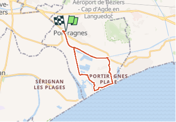

Length
11.8 km

Max alt
11 m

Uphill gradient
56 m
Km-Effort
12.6 km

Min alt
-2 m

Downhill gradient
57 m
Boucle
Yes
Creation date :
2024-06-12 12:47:21.95
Updated on :
2024-06-12 16:29:25.97
3h00
Difficulty : Very easy

FREE GPS app for hiking
 SityTrail
IGN / Geographical institutes
SityTrail Plus
The world is yours!
About
Trail Walking of 11.8 km to be discovered at Occitania, Hérault, Portiragnes. This trail is proposed by Daron34.
Description
boucle de 12kms avec traversée de l étang de la grande maïre
Positioning
Country:
France
Region :
Occitania
Department/Province :
Hérault
Municipality :
Portiragnes
Location:
Unknown
Start:(Dec)
Start:(UTM)
526902 ; 4794668 (31T) N.
Comments