


Chao de montselgues

raab
User
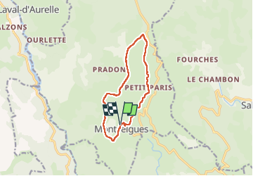

Length
11.3 km

Max alt
1143 m

Uphill gradient
257 m
Km-Effort
14.7 km

Min alt
980 m

Downhill gradient
256 m
Boucle
Yes
Creation date :
2024-06-13 08:01:33.427
Updated on :
2024-06-13 12:57:19.717
4h54
Difficulty : Difficult

FREE GPS app for hiking
 SityTrail
IGN / Geographical institutes
SityTrail Plus
The world is yours!
About
Trail Walking of 11.3 km to be discovered at Auvergne-Rhône-Alpes, Ardèche, Montselgues. This trail is proposed by raab.
Positioning
Country:
France
Region :
Auvergne-Rhône-Alpes
Department/Province :
Ardèche
Municipality :
Montselgues
Location:
Unknown
Start:(Dec)
Start:(UTM)
579936 ; 4930668 (31T) N.
Comments