


rando 1

Tommy Eric
User
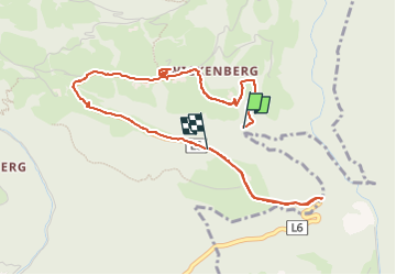

Length
4.9 km

Max alt
1009 m

Uphill gradient
191 m
Km-Effort
7.2 km

Min alt
888 m

Downhill gradient
117 m
Boucle
No
Creation date :
2024-06-13 09:56:45.914
Updated on :
2024-06-13 13:03:31.244
3h06
Difficulty : Medium

FREE GPS app for hiking
 SityTrail
IGN / Geographical institutes
SityTrail Plus
The world is yours!
About
Trail Walking of 4.9 km to be discovered at Carinthia, Bezirk Spittal an der Drau, Oberdrauburg. This trail is proposed by Tommy Eric.
Positioning
Country:
Austria
Region :
Carinthia
Department/Province :
Bezirk Spittal an der Drau
Municipality :
Oberdrauburg
Location:
Unknown
Start:(Dec)
Start:(UTM)
346248 ; 5180568 (33T) N.
Comments