


Champigneulles

topnature !
User
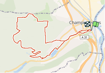

Length
12.6 km

Max alt
361 m

Uphill gradient
212 m
Km-Effort
15.5 km

Min alt
196 m

Downhill gradient
214 m
Boucle
Yes
Creation date :
2024-06-13 11:57:15.0
Updated on :
2024-06-13 15:33:40.046
2h57
Difficulty : Medium

FREE GPS app for hiking
 SityTrail
IGN / Geographical institutes
SityTrail Plus
The world is yours!
About
Trail Walking of 12.6 km to be discovered at Grand Est, Meurthe-et-Moselle, Champigneulles. This trail is proposed by topnature !.
Description
Champigneulles
Positioning
Country:
France
Region :
Grand Est
Department/Province :
Meurthe-et-Moselle
Municipality :
Champigneulles
Location:
Unknown
Start:(Dec)
Start:(UTM)
291839 ; 5401410 (32U) N.
Comments