


roche canon Fontainebleau

jacquesduchesne
User
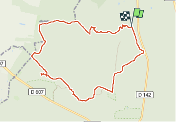

Length
10.4 km

Max alt
152 m

Uphill gradient
157 m
Km-Effort
12.5 km

Min alt
86 m

Downhill gradient
157 m
Boucle
Yes
Creation date :
2024-06-13 13:08:12.761
Updated on :
2024-06-13 15:47:42.283
2h38
Difficulty : Difficult

FREE GPS app for hiking
 SityTrail
IGN / Geographical institutes
SityTrail Plus
The world is yours!
About
Trail Walking of 10.4 km to be discovered at Ile-de-France, Seine-et-Marne, Fontainebleau. This trail is proposed by jacquesduchesne.
Positioning
Country:
France
Region :
Ile-de-France
Department/Province :
Seine-et-Marne
Municipality :
Fontainebleau
Location:
Unknown
Start:(Dec)
Start:(UTM)
475266 ; 5367886 (31U) N.
Comments