


doncourt cites - fort de fermont

jcb48
User
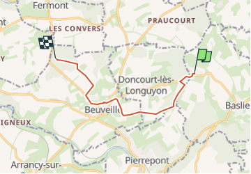

Length
8 km

Max alt
363 m

Uphill gradient
134 m
Km-Effort
9.9 km

Min alt
250 m

Downhill gradient
164 m
Boucle
No
Creation date :
2024-06-15 15:21:15.161
Updated on :
2024-06-15 15:22:21.695
2h14
Difficulty : Easy

FREE GPS app for hiking
 SityTrail
IGN / Geographical institutes
SityTrail Plus
The world is yours!
About
Trail On foot of 8 km to be discovered at Grand Est, Meurthe-et-Moselle, Baslieux. This trail is proposed by jcb48.
Description
marche
Positioning
Country:
France
Region :
Grand Est
Department/Province :
Meurthe-et-Moselle
Municipality :
Baslieux
Location:
Unknown
Start:(Dec)
Start:(UTM)
698330 ; 5480488 (31U) N.
Comments