


St Philippe Max

mouchette94
User
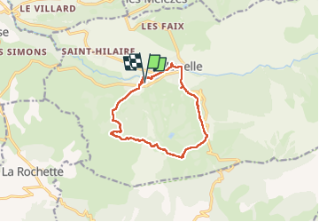

Length
12.2 km

Max alt
1687 m

Uphill gradient
472 m
Km-Effort
18.5 km

Min alt
1305 m

Downhill gradient
470 m
Boucle
Yes
Creation date :
2024-06-16 07:04:54.0
Updated on :
2024-06-16 15:17:08.878
4h10
Difficulty : Medium

FREE GPS app for hiking
 SityTrail
IGN / Geographical institutes
SityTrail Plus
The world is yours!
About
Trail Walking of 12.2 km to be discovered at Provence-Alpes-Côte d'Azur, Hautes-Alpes, Ancelle. This trail is proposed by mouchette94.
Positioning
Country:
France
Region :
Provence-Alpes-Côte d'Azur
Department/Province :
Hautes-Alpes
Municipality :
Ancelle
Location:
Unknown
Start:(Dec)
Start:(UTM)
277452 ; 4944447 (32T) N.
Comments