


Mazerac source lere belli y

Glurps
User
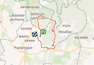

Length
11.5 km

Max alt
282 m

Uphill gradient
182 m
Km-Effort
13.9 km

Min alt
182 m

Downhill gradient
166 m
Boucle
No
Creation date :
2024-06-16 12:28:59.0
Updated on :
2024-06-16 15:34:00.762

FREE GPS app for hiking
 SityTrail
IGN / Geographical institutes
SityTrail Plus
The world is yours!
About
Trail of 11.5 km to be discovered at Occitania, Tarn-et-Garonne, Puylaroque. This trail is proposed by Glurps.
Photos


Positioning
Country:
France
Region :
Occitania
Department/Province :
Tarn-et-Garonne
Municipality :
Puylaroque
Location:
Unknown
Start:(Dec)
Start:(UTM)
390923 ; 4901821 (31T) N.
Comments