


avant before 2ème

planets
User

Length
17.3 km

Max alt
108 m

Uphill gradient
366 m
Km-Effort
22 km

Min alt
1 m

Downhill gradient
282 m
Boucle
No
Creation date :
2024-06-16 11:09:21.932
Updated on :
2024-06-16 17:35:51.587
4h45
Difficulty : Medium

FREE GPS app for hiking
 SityTrail
IGN / Geographical institutes
SityTrail Plus
The world is yours!
About
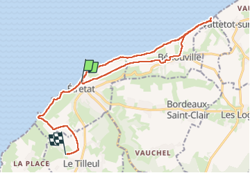
Trail Walking of 17.3 km to be discovered at Normandy, Seine-Maritime, Étretat. This trail is proposed by planets.
Positioning
Country:
France
Region :
Normandy
Department/Province :
Seine-Maritime
Municipality :
Étretat
Location:
Unknown
Start:(Dec)
Start:(UTM)
298406 ; 5510088 (31U) N.
Comments