


az

thonyc
User GUIDE
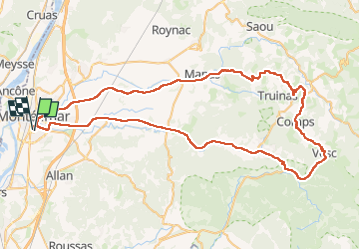

Length
87 km

Max alt
750 m

Uphill gradient
1194 m
Km-Effort
103 km

Min alt
83 m

Downhill gradient
1198 m
Boucle
Yes
Creation date :
2024-06-18 06:53:04.595
Updated on :
2024-06-18 11:30:02.919
4h36
Difficulty : Easy

FREE GPS app for hiking
 SityTrail
IGN / Geographical institutes
SityTrail Plus
The world is yours!
About
Trail Road bike of 87 km to be discovered at Auvergne-Rhône-Alpes, Drôme, Montélimar. This trail is proposed by thonyc.
Positioning
Country:
France
Region :
Auvergne-Rhône-Alpes
Department/Province :
Drôme
Municipality :
Montélimar
Location:
Unknown
Start:(Dec)
Start:(UTM)
639182 ; 4933787 (31T) N.
Comments