


course

luccho
User
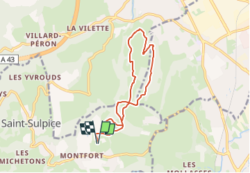

Length
7.1 km

Max alt
478 m

Uphill gradient
211 m
Km-Effort
9.9 km

Min alt
318 m

Downhill gradient
211 m
Boucle
Yes
Creation date :
2024-06-20 14:47:36.148
Updated on :
2024-06-20 14:47:37.608
1h00
Difficulty : Very easy

FREE GPS app for hiking
 SityTrail
IGN / Geographical institutes
SityTrail Plus
The world is yours!
About
Trail Trail of 7.1 km to be discovered at Auvergne-Rhône-Alpes, Savoy, Saint-Sulpice. This trail is proposed by luccho.
Positioning
Country:
France
Region :
Auvergne-Rhône-Alpes
Department/Province :
Savoy
Municipality :
Saint-Sulpice
Location:
Unknown
Start:(Dec)
Start:(UTM)
723304 ; 5049597 (31T) N.
Comments