


Bouillouses M A F

fb30
User
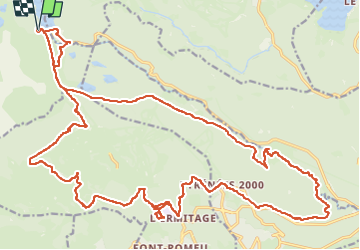

Length
36 km

Max alt
2202 m

Uphill gradient
900 m
Km-Effort
48 km

Min alt
1653 m

Downhill gradient
896 m
Boucle
Yes
Creation date :
2024-06-22 07:12:28.0
Updated on :
2024-06-22 12:22:53.537

FREE GPS app for hiking
 SityTrail
IGN / Geographical institutes
SityTrail Plus
The world is yours!
About
Trail of 36 km to be discovered at Occitania, Pyrénées-Orientales, Angoustrine-Villeneuve-des-Escaldes. This trail is proposed by fb30.
Positioning
Country:
France
Region :
Occitania
Department/Province :
Pyrénées-Orientales
Municipality :
Angoustrine-Villeneuve-des-Escaldes
Location:
Unknown
Start:(Dec)
Start:(UTM)
417632 ; 4712479 (31T) N.
Comments