


Rando briancon

patign
User
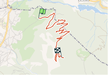

Length
4.6 km

Max alt
1787 m

Uphill gradient
480 m
Km-Effort
9.5 km

Min alt
1319 m

Downhill gradient
17 m
Boucle
No
Creation date :
2024-06-22 17:06:08.0
Updated on :
2024-06-22 18:45:27.07
1h38
Difficulty : Medium

FREE GPS app for hiking
 SityTrail
IGN / Geographical institutes
SityTrail Plus
The world is yours!
About
Trail Walking of 4.6 km to be discovered at Provence-Alpes-Côte d'Azur, Hautes-Alpes, Villar-Saint-Pancrace. This trail is proposed by patign.
Positioning
Country:
France
Region :
Provence-Alpes-Côte d'Azur
Department/Province :
Hautes-Alpes
Municipality :
Villar-Saint-Pancrace
Location:
Unknown
Start:(Dec)
Start:(UTM)
313749 ; 4972398 (32T) N.
Comments