


Jour 2

patign
User
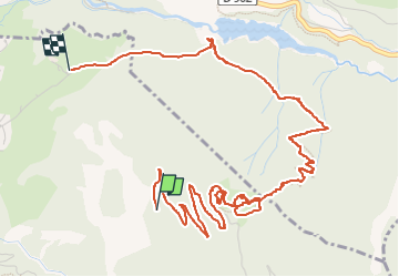

Length
6.9 km

Max alt
2002 m

Uphill gradient
245 m
Km-Effort
11.7 km

Min alt
1317 m

Downhill gradient
707 m
Boucle
No
Creation date :
2024-06-23 07:25:52.0
Updated on :
2024-06-23 10:15:05.381
2h49
Difficulty : Medium

FREE GPS app for hiking
 SityTrail
IGN / Geographical institutes
SityTrail Plus
The world is yours!
About
Trail Walking of 6.9 km to be discovered at Provence-Alpes-Côte d'Azur, Hautes-Alpes, Villar-Saint-Pancrace. This trail is proposed by patign.
Positioning
Country:
France
Region :
Provence-Alpes-Côte d'Azur
Department/Province :
Hautes-Alpes
Municipality :
Villar-Saint-Pancrace
Location:
Unknown
Start:(Dec)
Start:(UTM)
314253 ; 4971516 (32T) N.
Comments