


lac d'oo + lac espringlo

Bruno566
User
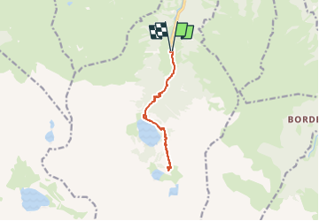

Length
12.7 km

Max alt
1973 m

Uphill gradient
904 m
Km-Effort
25 km

Min alt
1128 m

Downhill gradient
910 m
Boucle
Yes
Creation date :
2024-06-23 13:18:33.912
Updated on :
2024-06-23 13:19:17.345
5h38
Difficulty : Easy

FREE GPS app for hiking
 SityTrail
IGN / Geographical institutes
SityTrail Plus
The world is yours!
About
Trail Walking of 12.7 km to be discovered at Occitania, Haute-Garonne, Oô. This trail is proposed by Bruno566.
Positioning
Country:
France
Region :
Occitania
Department/Province :
Haute-Garonne
Municipality :
Oô
Location:
Unknown
Start:(Dec)
Start:(UTM)
295565 ; 4737621 (31T) N.
Comments