


Voie verte

jean52
User

Length
3.4 km

Max alt
226 m

Uphill gradient
22 m
Km-Effort
3.6 km

Min alt
210 m

Downhill gradient
13 m
Boucle
No
Creation date :
2024-06-23 14:07:47.0
Updated on :
2024-06-23 14:48:18.22
40m
Difficulty : Easy

FREE GPS app for hiking
 SityTrail
IGN / Geographical institutes
SityTrail Plus
The world is yours!
About
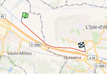
Trail Walking of 3.4 km to be discovered at Auvergne-Rhône-Alpes, Isère, Vaulx-Milieu. This trail is proposed by jean52.
Positioning
Country:
France
Region :
Auvergne-Rhône-Alpes
Department/Province :
Isère
Municipality :
Vaulx-Milieu
Location:
Unknown
Start:(Dec)
Start:(UTM)
670207 ; 5054702 (31T) N.
Comments