


Diois 2024 2ème

planets
User
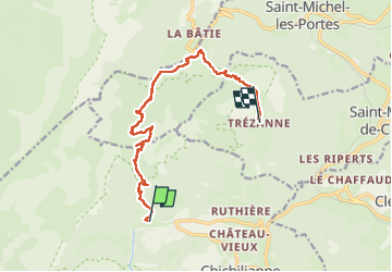

Length
13.8 km

Max alt
1708 m

Uphill gradient
850 m
Km-Effort
25 km

Min alt
1021 m

Downhill gradient
901 m
Boucle
No
Creation date :
2024-06-23 07:23:59.823
Updated on :
2024-06-23 14:50:21.693
4h31
Difficulty : Medium

FREE GPS app for hiking
 SityTrail
IGN / Geographical institutes
SityTrail Plus
The world is yours!
About
Trail Walking of 13.8 km to be discovered at Auvergne-Rhône-Alpes, Isère, Chichilianne. This trail is proposed by planets.
Positioning
Country:
France
Region :
Auvergne-Rhône-Alpes
Department/Province :
Isère
Municipality :
Chichilianne
Location:
Unknown
Start:(Dec)
Start:(UTM)
701222 ; 4966426 (31T) N.
Comments