


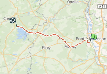
PAM LAC DE LA MADINE

nouga
User

Length
33 km

Max alt
342 m

Uphill gradient
460 m
Km-Effort
39 km

Min alt
179 m

Downhill gradient
415 m
Boucle
No
Creation date :
2024-06-23 22:58:42.923
Updated on :
2024-06-23 23:00:19.366
2h43
Difficulty : Difficult

FREE GPS app for hiking
 SityTrail
IGN / Geographical institutes
SityTrail Plus
The world is yours!
About
Trail Mountain bike of 33 km to be discovered at Grand Est, Meurthe-et-Moselle, Blénod-lès-Pont-à-Mousson. This trail is proposed by nouga.
Positioning
Country:
France
Region :
Grand Est
Department/Province :
Meurthe-et-Moselle
Municipality :
Blénod-lès-Pont-à-Mousson
Location:
Unknown
Start:(Dec)
Start:(UTM)
283777 ; 5419161 (32U) N.
Comments