


les Borrels 2 chapeau de Charlemagne

giovannoni
User
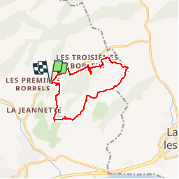

Length
13.7 km

Max alt
227 m

Uphill gradient
426 m
Km-Effort
19.4 km

Min alt
39 m

Downhill gradient
426 m
Boucle
Yes
Creation date :
2015-04-20 00:00:00.0
Updated on :
2015-04-20 00:00:00.0
4h50
Difficulty : Difficult

FREE GPS app for hiking
 SityTrail
IGN / Geographical institutes
SityTrail Plus
The world is yours!
About
Trail Walking of 13.7 km to be discovered at Provence-Alpes-Côte d'Azur, Var, Hyères. This trail is proposed by giovannoni.
Positioning
Country:
France
Region :
Provence-Alpes-Côte d'Azur
Department/Province :
Var
Municipality :
Hyères
Location:
Unknown
Start:(Dec)
Start:(UTM)
269648 ; 4782263 (32T) N.
Comments