


240624 - Obernai échauffement

randodan
User
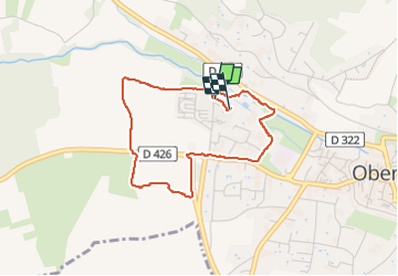

Length
3.4 km

Max alt
218 m

Uphill gradient
30 m
Km-Effort
3.8 km

Min alt
191 m

Downhill gradient
30 m
Boucle
Yes
Creation date :
2024-06-24 08:22:34.614
Updated on :
2024-06-24 09:40:12.158
1h17
Difficulty : Easy

FREE GPS app for hiking
 SityTrail
IGN / Geographical institutes
SityTrail Plus
The world is yours!
About
Trail Walking of 3.4 km to be discovered at Grand Est, Bas-Rhin, Obernai. This trail is proposed by randodan.
Description
1ère foulée au soleil matinal mais déjà bien chaud
Photos


Positioning
Country:
France
Region :
Grand Est
Department/Province :
Bas-Rhin
Municipality :
Obernai
Location:
Unknown
Start:(Dec)
Start:(UTM)
386761 ; 5369246 (32U) N.
Comments