


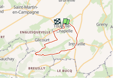
TOURVILLE LA CHAPELLE

juanluco76
User

Length
10.7 km

Max alt
147 m

Uphill gradient
120 m
Km-Effort
12.3 km

Min alt
63 m

Downhill gradient
120 m
Boucle
Yes
Creation date :
2024-06-24 18:04:36.762
Updated on :
2024-06-24 18:05:34.683
2h47
Difficulty : Difficult

FREE GPS app for hiking
 SityTrail
IGN / Geographical institutes
SityTrail Plus
The world is yours!
About
Trail Walking of 10.7 km to be discovered at Normandy, Seine-Maritime, Petit-Caux. This trail is proposed by juanluco76.
Positioning
Country:
France
Region :
Normandy
Department/Province :
Seine-Maritime
Municipality :
Petit-Caux
Location:
Tourville-la-Chapelle
Start:(Dec)
Start:(UTM)
375283 ; 5533772 (31U) N.
Comments