


Langogne - Cheylard

nolsim
User
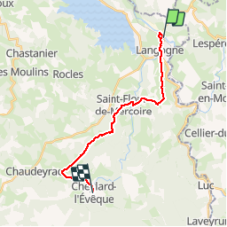

Length
18.4 km

Max alt
1236 m

Uphill gradient
485 m
Km-Effort
24 km

Min alt
901 m

Downhill gradient
269 m
Boucle
No
Creation date :
2018-08-18 14:09:12.744
Updated on :
2018-08-18 14:09:12.744
--
Difficulty : Medium

FREE GPS app for hiking
 SityTrail
IGN / Geographical institutes
SityTrail Plus
The world is yours!
About
Trail Walking of 18.4 km to be discovered at Occitania, Lozère, Langogne. This trail is proposed by nolsim.
Positioning
Country:
France
Region :
Occitania
Department/Province :
Lozère
Municipality :
Langogne
Location:
Unknown
Start:(Dec)
Start:(UTM)
567906 ; 4953748 (31T) N.
Comments