


Karlsruher Gray

patign
User
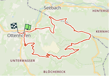

Length
13.2 km

Max alt
834 m

Uphill gradient
662 m
Km-Effort
22 km

Min alt
304 m

Downhill gradient
692 m
Boucle
No
Creation date :
2024-06-25 09:33:38.0
Updated on :
2024-06-25 17:14:44.574
4h17
Difficulty : Unknown

FREE GPS app for hiking
 SityTrail
IGN / Geographical institutes
SityTrail Plus
The world is yours!
About
Trail Walking of 13.2 km to be discovered at Baden-Württemberg, Ortenaukreis, Ottenhöfen im Schwarzwald. This trail is proposed by patign.
Description
Départ ottenhofen
Photos


Positioning
Country:
Germany
Region :
Baden-Württemberg
Department/Province :
Ortenaukreis
Municipality :
Ottenhöfen im Schwarzwald
Location:
Unknown
Start:(Dec)
Start:(UTM)
437656 ; 5379605 (32U) N.
Comments