


brevet du rando de chenove 2015

florianlive
User
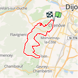

Length
28 km

Max alt
532 m

Uphill gradient
639 m
Km-Effort
37 km

Min alt
292 m

Downhill gradient
642 m
Boucle
Yes
Creation date :
2015-04-20 00:00:00.0
Updated on :
2015-04-20 00:00:00.0
6h45
Difficulty : Medium

FREE GPS app for hiking
 SityTrail
IGN / Geographical institutes
SityTrail Plus
The world is yours!
About
Trail Walking of 28 km to be discovered at Bourgogne-Franche-Comté, Côte-d'Or, Chenôve. This trail is proposed by florianlive.
Positioning
Country:
France
Region :
Bourgogne-Franche-Comté
Department/Province :
Côte-d'Or
Municipality :
Chenôve
Location:
Unknown
Start:(Dec)
Start:(UTM)
650950 ; 5240304 (31T) N.
Comments