


240627 - Obernai - SteOdile.murPayen.sentmerv

randodan
User
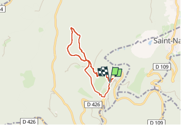

Length
5.7 km

Max alt
762 m

Uphill gradient
174 m
Km-Effort
8 km

Min alt
591 m

Downhill gradient
168 m
Boucle
Yes
Creation date :
2024-06-27 08:10:16.889
Updated on :
2024-06-29 10:40:42.374
1h49
Difficulty : Medium

FREE GPS app for hiking
 SityTrail
IGN / Geographical institutes
SityTrail Plus
The world is yours!
About
Trail Walking of 5.7 km to be discovered at Grand Est, Bas-Rhin, Ottrott. This trail is proposed by randodan.
Description
pour autres photos voir 2015
Photos


Positioning
Country:
France
Region :
Grand Est
Department/Province :
Bas-Rhin
Municipality :
Ottrott
Location:
Unknown
Start:(Dec)
Start:(UTM)
381848 ; 5366010 (32U) N.
Comments