


correncon - cab de Roybon - Corrençon

CABERMAT
User
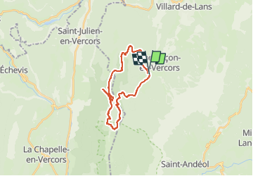

Length
22 km

Max alt
1461 m

Uphill gradient
547 m
Km-Effort
29 km

Min alt
1154 m

Downhill gradient
563 m
Boucle
Yes
Creation date :
2024-06-27 08:19:14.533
Updated on :
2024-06-27 12:24:26.39
4h04
Difficulty : Medium

FREE GPS app for hiking
 SityTrail
IGN / Geographical institutes
SityTrail Plus
The world is yours!
About
Trail Mountain bike of 22 km to be discovered at Auvergne-Rhône-Alpes, Isère, Corrençon-en-Vercors. This trail is proposed by CABERMAT.
Positioning
Country:
France
Region :
Auvergne-Rhône-Alpes
Department/Province :
Isère
Municipality :
Corrençon-en-Vercors
Location:
Unknown
Start:(Dec)
Start:(UTM)
698212 ; 4988708 (31T) N.
Comments