


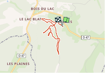
Sentier des Fontaines

Gegetop
User

Length
3.6 km

Max alt
269 m

Uphill gradient
115 m
Km-Effort
5.2 km

Min alt
190 m

Downhill gradient
118 m
Boucle
Yes
Creation date :
2024-06-27 12:55:10.494
Updated on :
2024-06-27 14:30:18.824
1h33
Difficulty : Easy

FREE GPS app for hiking
 SityTrail
IGN / Geographical institutes
SityTrail Plus
The world is yours!
About
Trail Walking of 3.6 km to be discovered at New Aquitaine, Dordogne, Salignac-Eyvigues. This trail is proposed by Gegetop.
Description
Eyvigues
Photos


Positioning
Country:
France
Region :
New Aquitaine
Department/Province :
Dordogne
Municipality :
Salignac-Eyvigues
Location:
Unknown
Start:(Dec)
Start:(UTM)
370759 ; 4976966 (31T) N.
Comments