


2024-06-27_22h32m22_J5 col de GRANON..

okfred26
User
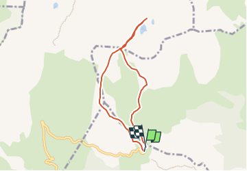

Length
6.6 km

Max alt
2555 m

Uphill gradient
312 m
Km-Effort
10.7 km

Min alt
2369 m

Downhill gradient
307 m
Boucle
Yes
Creation date :
2024-06-27 20:32:22.238
Updated on :
2024-06-27 20:35:53.16
2h26
Difficulty : Medium

FREE GPS app for hiking
 SityTrail
IGN / Geographical institutes
SityTrail Plus
The world is yours!
About
Trail Walking of 6.6 km to be discovered at Provence-Alpes-Côte d'Azur, Hautes-Alpes, Saint-Chaffrey. This trail is proposed by okfred26.
Description
grp_trc:
Positioning
Country:
France
Region :
Provence-Alpes-Côte d'Azur
Department/Province :
Hautes-Alpes
Municipality :
Saint-Chaffrey
Location:
Unknown
Start:(Dec)
Start:(UTM)
311562 ; 4981571 (32T) N.
Comments