


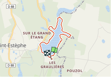
Grand étang de St.Estephe

rigol05
User

Length
3.2 km

Max alt
238 m

Uphill gradient
16 m
Km-Effort
3.4 km

Min alt
230 m

Downhill gradient
15 m
Boucle
Yes
Creation date :
2024-06-28 10:21:29.163
Updated on :
2024-06-28 11:20:33.673
51m
Difficulty : Easy

FREE GPS app for hiking
 SityTrail
IGN / Geographical institutes
SityTrail Plus
The world is yours!
About
Trail Walking of 3.2 km to be discovered at New Aquitaine, Dordogne, Saint-Estèphe. This trail is proposed by rigol05.
Positioning
Country:
France
Region :
New Aquitaine
Department/Province :
Dordogne
Municipality :
Saint-Estèphe
Location:
Unknown
Start:(Dec)
Start:(UTM)
318604 ; 5051156 (31T) N.
Comments