


2024 06 Malandry t1

michel1025
User
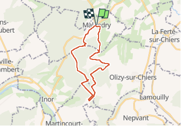

Length
12.3 km

Max alt
347 m

Uphill gradient
262 m
Km-Effort
15.8 km

Min alt
186 m

Downhill gradient
261 m
Boucle
Yes
Creation date :
2024-06-28 11:44:46.0
Updated on :
2024-06-28 14:54:51.517
3h09
Difficulty : Difficult

FREE GPS app for hiking
 SityTrail
IGN / Geographical institutes
SityTrail Plus
The world is yours!
About
Trail Walking of 12.3 km to be discovered at Grand Est, Ardennes, Malandry. This trail is proposed by michel1025.
Positioning
Country:
France
Region :
Grand Est
Department/Province :
Ardennes
Municipality :
Malandry
Location:
Unknown
Start:(Dec)
Start:(UTM)
658691 ; 5494154 (31U) N.
Comments