


De Nemours à Montigny sur Loing

jpcccb
User
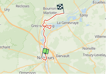

Length
16.2 km

Max alt
89 m

Uphill gradient
136 m
Km-Effort
18 km

Min alt
54 m

Downhill gradient
117 m
Boucle
No
Creation date :
2024-06-28 15:45:43.487
Updated on :
2024-07-01 09:13:59.356
4h05
Difficulty : Difficult

FREE GPS app for hiking
 SityTrail
IGN / Geographical institutes
SityTrail Plus
The world is yours!
About
Trail Walking of 16.2 km to be discovered at Ile-de-France, Seine-et-Marne, Saint-Pierre-lès-Nemours. This trail is proposed by jpcccb.
Positioning
Country:
France
Region :
Ile-de-France
Department/Province :
Seine-et-Marne
Municipality :
Saint-Pierre-lès-Nemours
Location:
Unknown
Start:(Dec)
Start:(UTM)
476704 ; 5346094 (31U) N.
Comments