


fort de la Hougue

gdela
User
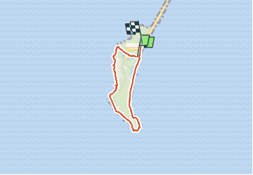

Length
2 km

Max alt
12 m

Uphill gradient
8 m
Km-Effort
2.2 km

Min alt
-1 m

Downhill gradient
9 m
Boucle
Yes
Creation date :
2024-06-29 15:38:34.902
Updated on :
2024-06-29 16:18:53.089
30m
Difficulty : Easy

FREE GPS app for hiking
 SityTrail
IGN / Geographical institutes
SityTrail Plus
The world is yours!
About
Trail Walking of 2 km to be discovered at Normandy, Manche, Saint-Vaast-la-Hougue. This trail is proposed by gdela.
Description
faire dans le sens indiqué.
Positioning
Country:
France
Region :
Normandy
Department/Province :
Manche
Municipality :
Saint-Vaast-la-Hougue
Location:
Unknown
Start:(Dec)
Start:(UTM)
624871 ; 5492997 (30U) N.
Comments