


2024-06-30_08h33m01_24_06_30_CA_total

Pirard
User
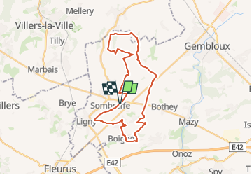

Length
27 km

Max alt
175 m

Uphill gradient
244 m
Km-Effort
31 km

Min alt
119 m

Downhill gradient
243 m
Boucle
Yes
Creation date :
2024-06-30 06:33:01.429
Updated on :
2024-06-30 06:33:05.146

FREE GPS app for hiking
 SityTrail
IGN / Geographical institutes
SityTrail Plus
The world is yours!
About
Trail of 27 km to be discovered at Wallonia, Namur, Sombreffe. This trail is proposed by Pirard .
Positioning
Country:
Belgium
Region :
Wallonia
Department/Province :
Namur
Municipality :
Sombreffe
Location:
Unknown
Start:(Dec)
Start:(UTM)
614054 ; 5598100 (31U) N.
Comments