


moustiirac

bourdet
User

Length
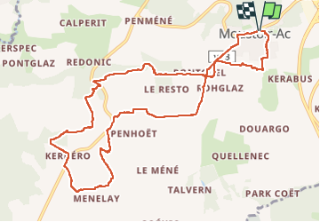
11.8 km

Max alt
121 m

Uphill gradient
179 m
Km-Effort
14.2 km

Min alt
71 m

Downhill gradient
179 m
Boucle
Yes
Creation date :
2024-06-30 08:39:32.281
Updated on :
2024-06-30 12:00:56.886
3h20
Difficulty : Difficult

FREE GPS app for hiking
 SityTrail
IGN / Geographical institutes
SityTrail Plus
The world is yours!
About
Trail Walking of 11.8 km to be discovered at Brittany, Morbihan, Moustoir-Ac. This trail is proposed by bourdet.
Photos


Positioning
Country:
France
Region :
Brittany
Department/Province :
Morbihan
Municipality :
Moustoir-Ac
Location:
Unknown
Start:(Dec)
Start:(UTM)
512382 ; 5300240 (30T) N.
Comments