


ambleuteuse

Djaie60
User

Length
9.1 km

Max alt
48 m

Uphill gradient
139 m
Km-Effort
10.8 km

Min alt
3 m

Downhill gradient
101 m
Boucle
No
Creation date :
2019-04-12 07:41:51.034
Updated on :
2019-05-01 14:22:05.087
2h22
Difficulty : Medium

FREE GPS app for hiking
 SityTrail
IGN / Geographical institutes
SityTrail Plus
The world is yours!
About
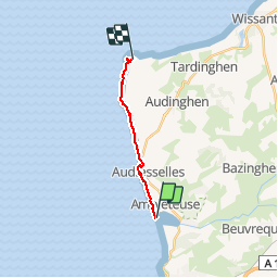
Trail Walking of 9.1 km to be discovered at Hauts-de-France, Pas-de-Calais, Ambleteuse. This trail is proposed by Djaie60.
Positioning
Country:
France
Region :
Hauts-de-France
Department/Province :
Pas-de-Calais
Municipality :
Ambleteuse
Location:
Unknown
Start:(Dec)
Start:(UTM)
401432 ; 5629205 (31U) N.
Comments