


Reco Alex 30 juin

Aloux95
User
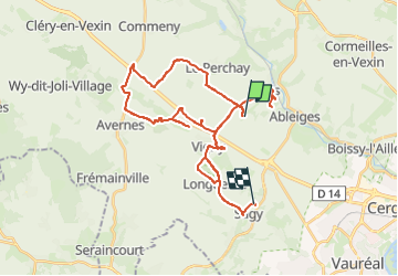

Length
38 km

Max alt
137 m

Uphill gradient
417 m
Km-Effort
44 km

Min alt
45 m

Downhill gradient
454 m
Boucle
No
Creation date :
2024-06-30 15:14:31.0
Updated on :
2024-06-30 17:48:27.458

FREE GPS app for hiking
 SityTrail
IGN / Geographical institutes
SityTrail Plus
The world is yours!
About
Trail of 38 km to be discovered at Ile-de-France, Val-d'Oise, Us. This trail is proposed by Aloux95.
Positioning
Country:
France
Region :
Ile-de-France
Department/Province :
Val-d'Oise
Municipality :
Us
Location:
Unknown
Start:(Dec)
Start:(UTM)
423331 ; 5437973 (31U) N.
Comments