


romain

fays12
User
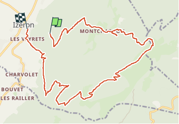

Length
13.3 km

Max alt
1186 m

Uphill gradient
854 m
Km-Effort
25 km

Min alt
245 m

Downhill gradient
996 m
Boucle
No
Creation date :
2024-06-30 13:41:35.127
Updated on :
2024-07-01 06:23:22.445
2h11
Difficulty : Very easy

FREE GPS app for hiking
 SityTrail
IGN / Geographical institutes
SityTrail Plus
The world is yours!
About
Trail Trail of 13.3 km to be discovered at Auvergne-Rhône-Alpes, Isère, Izeron. This trail is proposed by fays12.
Positioning
Country:
France
Region :
Auvergne-Rhône-Alpes
Department/Province :
Isère
Municipality :
Izeron
Location:
Unknown
Start:(Dec)
Start:(UTM)
687433 ; 5001807 (31T) N.
Comments