


Pk Ratery - Col des Champs

LtZIP
User
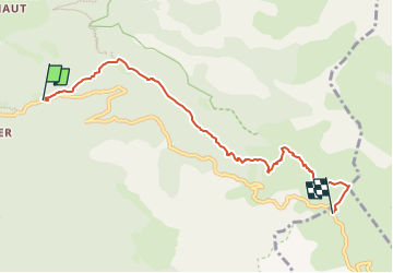

Length
6.2 km

Max alt
2086 m

Uphill gradient
402 m
Km-Effort
10.3 km

Min alt
1688 m

Downhill gradient
11 m
Boucle
No
Creation date :
2024-07-01 09:33:29.209
Updated on :
2024-07-07 15:38:14.855
2h20
Difficulty : Medium

FREE GPS app for hiking
 SityTrail
IGN / Geographical institutes
SityTrail Plus
The world is yours!
About
Trail Walking of 6.2 km to be discovered at Provence-Alpes-Côte d'Azur, Alpes-de-Haute-Provence, Colmars. This trail is proposed by LtZIP.
Description
IBP
Bleu 45
Photos


Positioning
Country:
France
Region :
Provence-Alpes-Côte d'Azur
Department/Province :
Alpes-de-Haute-Provence
Municipality :
Colmars
Location:
Unknown
Start:(Dec)
Start:(UTM)
312400 ; 4895340 (32T) N.
Comments