


Azay le ferron

Dupuybadonniere
User
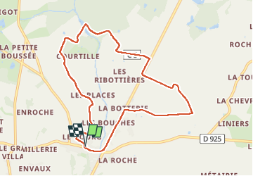

Length
9.4 km

Max alt
136 m

Uphill gradient
91 m
Km-Effort
10.6 km

Min alt
100 m

Downhill gradient
91 m
Boucle
Yes
Creation date :
2024-07-02 07:38:38.75
Updated on :
2024-07-02 10:17:55.004
2h38
Difficulty : Very easy

FREE GPS app for hiking
 SityTrail
IGN / Geographical institutes
SityTrail Plus
The world is yours!
About
Trail Walking of 9.4 km to be discovered at Centre-Loire Valley, Indre, Azay-le-Ferron. This trail is proposed by Dupuybadonniere.
Positioning
Country:
France
Region :
Centre-Loire Valley
Department/Province :
Indre
Municipality :
Azay-le-Ferron
Location:
Unknown
Start:(Dec)
Start:(UTM)
352855 ; 5190472 (31T) N.
Comments