


Bellignat la combe de Léchaud Bellignat

cailloux54
User
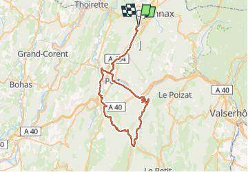

Length
60 km

Max alt
1001 m

Uphill gradient
923 m
Km-Effort
73 km

Min alt
476 m

Downhill gradient
920 m
Boucle
Yes
Creation date :
2024-07-02 07:09:25.198
Updated on :
2024-07-02 10:41:36.52
3h21
Difficulty : Medium

FREE GPS app for hiking
 SityTrail
IGN / Geographical institutes
SityTrail Plus
The world is yours!
About
Trail Electric bike of 60 km to be discovered at Auvergne-Rhône-Alpes, Ain, Bellignat. This trail is proposed by cailloux54.
Positioning
Country:
France
Region :
Auvergne-Rhône-Alpes
Department/Province :
Ain
Municipality :
Bellignat
Location:
Unknown
Start:(Dec)
Start:(UTM)
702255 ; 5124042 (31T) N.
Comments