


col

MoiClaude
User

Length
14.3 km

Max alt
758 m

Uphill gradient
841 m
Km-Effort
26 km

Min alt
275 m

Downhill gradient
850 m
Boucle
No
Creation date :
2024-07-01 07:44:23.014
Updated on :
2024-07-02 10:57:27.706
6h07
Difficulty : Very difficult

FREE GPS app for hiking
 SityTrail
IGN / Geographical institutes
SityTrail Plus
The world is yours!
About
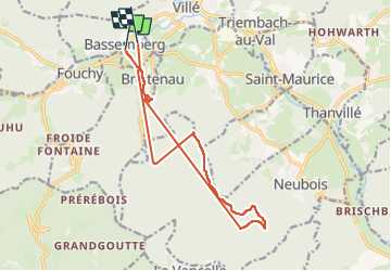
Trail Walking of 14.3 km to be discovered at Grand Est, Bas-Rhin, Bassemberg. This trail is proposed by MoiClaude.
Photos

Positioning
Country:
France
Region :
Grand Est
Department/Province :
Bas-Rhin
Municipality :
Bassemberg
Location:
Unknown
Start:(Dec)
Start:(UTM)
372836 ; 5354807 (32U) N.
Comments