


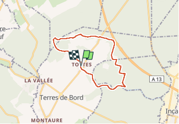
20240702-Tostes

doudet
User

Length
11.9 km

Max alt
147 m

Uphill gradient
152 m
Km-Effort
13.9 km

Min alt
70 m

Downhill gradient
154 m
Boucle
Yes
Creation date :
2024-07-02 11:50:51.907
Updated on :
2024-07-03 06:18:48.26
3h37
Difficulty : Medium

FREE GPS app for hiking
 SityTrail
IGN / Geographical institutes
SityTrail Plus
The world is yours!
About
Trail Walking of 11.9 km to be discovered at Normandy, Eure, Terres de Bord. This trail is proposed by doudet.
Description
Boucle A-R au départ de la salle des Fetes rue du Puits
Photos

Positioning
Country:
France
Region :
Normandy
Department/Province :
Eure
Municipality :
Terres de Bord
Location:
Tostes
Start:(Dec)
Start:(UTM)
362583 ; 5458007 (31U) N.
Comments