


Rocher de Dubé

Dupuybadonniere
User

Length
11.6 km

Max alt
128 m

Uphill gradient
152 m
Km-Effort
13.7 km

Min alt
74 m

Downhill gradient
152 m
Boucle
Yes
Creation date :
2024-07-03 07:58:14.815
Updated on :
2024-07-03 11:04:00.965
3h04
Difficulty : Very easy

FREE GPS app for hiking
 SityTrail
IGN / Geographical institutes
SityTrail Plus
The world is yours!
About
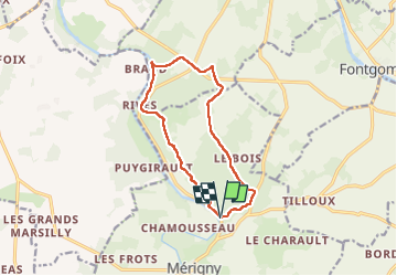
Trail Walking of 11.6 km to be discovered at Centre-Loire Valley, Indre, Mérigny. This trail is proposed by Dupuybadonniere.
Positioning
Country:
France
Region :
Centre-Loire Valley
Department/Province :
Indre
Municipality :
Mérigny
Location:
Unknown
Start:(Dec)
Start:(UTM)
341946 ; 5167498 (31T) N.
Comments