


roche merveilleuse le mont

tgvpatrickfavre
User
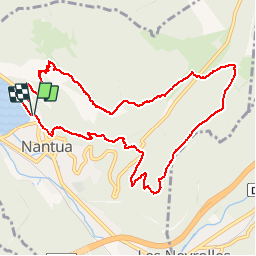

Length
10.9 km

Max alt
943 m

Uphill gradient
589 m
Km-Effort
18.8 km

Min alt
473 m

Downhill gradient
592 m
Boucle
Yes
Creation date :
2015-04-22 00:00:00.0
Updated on :
2015-04-22 00:00:00.0
2h56
Difficulty : Medium

FREE GPS app for hiking
 SityTrail
IGN / Geographical institutes
SityTrail Plus
The world is yours!
About
Trail Walking of 10.9 km to be discovered at Auvergne-Rhône-Alpes, Ain, Nantua. This trail is proposed by tgvpatrickfavre.
Description
tour sympa variante tour horizon avec descente par chemin techique
Positioning
Country:
France
Region :
Auvergne-Rhône-Alpes
Department/Province :
Ain
Municipality :
Nantua
Location:
Unknown
Start:(Dec)
Start:(UTM)
701045 ; 5114805 (31T) N.
Comments