


St JEANNET-MOUTON d'ANOU

ch2slv
User
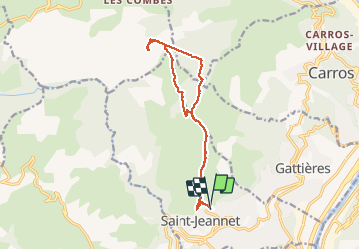

Length
14.6 km

Max alt
1074 m

Uphill gradient
631 m
Km-Effort
23 km

Min alt
443 m

Downhill gradient
658 m
Boucle
Yes
Creation date :
2015-04-22 00:00:00.0
Updated on :
2015-04-22 00:00:00.0
4h40
Difficulty : Medium

FREE GPS app for hiking
 SityTrail
IGN / Geographical institutes
SityTrail Plus
The world is yours!
About
Trail Walking of 14.6 km to be discovered at Provence-Alpes-Côte d'Azur, Maritime Alps, Saint-Jeannet. This trail is proposed by ch2slv.
Description
Depuis St JEANNET, pour changer du Baou, petite boucle dans la montagnes du CHIE, les pâtures à mouton, les yeuses et cailloux.
Positioning
Country:
France
Region :
Provence-Alpes-Côte d'Azur
Department/Province :
Maritime Alps
Municipality :
Saint-Jeannet
Location:
Unknown
Start:(Dec)
Start:(UTM)
350759 ; 4845931 (32T) N.
Comments