


Fays-Famenne MHL

fra_depoorter
User
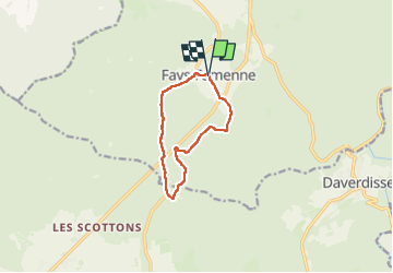

Length
8.4 km

Max alt
438 m

Uphill gradient
122 m
Km-Effort
10 km

Min alt
382 m

Downhill gradient
117 m
Boucle
Yes
Creation date :
2024-06-27 07:31:05.208
Updated on :
2024-07-04 14:14:45.373
2h05
Difficulty : Easy

FREE GPS app for hiking
 SityTrail
IGN / Geographical institutes
SityTrail Plus
The world is yours!
About
Trail Walking of 8.4 km to be discovered at Wallonia, Luxembourg, Wellin. This trail is proposed by fra_depoorter.
Positioning
Country:
Belgium
Region :
Wallonia
Department/Province :
Luxembourg
Municipality :
Wellin
Location:
Unknown
Start:(Dec)
Start:(UTM)
648304 ; 5545485 (31U) N.
Comments