


tours de.Montmayeur

begnez
User
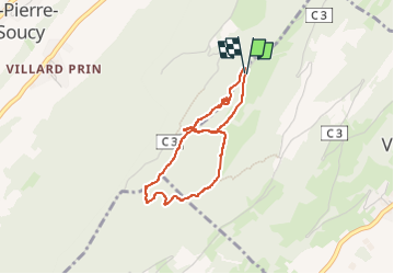

Length
3.2 km

Max alt
794 m

Uphill gradient
127 m
Km-Effort
4.9 km

Min alt
705 m

Downhill gradient
125 m
Boucle
Yes
Creation date :
2024-07-05 07:36:36.225
Updated on :
2024-07-05 09:16:03.318
1h34
Difficulty : Very easy

FREE GPS app for hiking
 SityTrail
IGN / Geographical institutes
SityTrail Plus
The world is yours!
About
Trail Walking of 3.2 km to be discovered at Auvergne-Rhône-Alpes, Savoy, Villard-Sallet. This trail is proposed by begnez.
Positioning
Country:
France
Region :
Auvergne-Rhône-Alpes
Department/Province :
Savoy
Municipality :
Villard-Sallet
Location:
Unknown
Start:(Dec)
Start:(UTM)
275391 ; 5041552 (32T) N.
Comments